I’m running ubuntu-eee on my new Asus Eee 901. And Firefox 3.0 was horrible on it. You’d load a page, and scrolling up and down would pause frequently with a jittery, jerky motion. It was so annoying that I experimented with Opera and Epiphany as replacements. Both fine browsers, but I hated being without add-ins like Adblock Plus and Foxmarks. Read on to find out how to fix it…
DRM-Free Music in the UK

(source: http://xkcd.com/488/)
Why is it so hard to legally obtain DRM-free music in the UK? Amazon, in the US, has offered DRM-free music downloads for a long time now. However their UK site doesn’t (and they don’t let you order music from the US-based site unless you are a US citizen). Tesco (www.tescodigital.com) offers some DRM-free stuff, but the site requires Windows clients and is slow and poorly designed. iTunes did start to offer some DRM-free stuff, but (a) it was more expensive and (b) the selection, when I last looked, was pitifully small.
Got to Get Past!
What is it on the roads today?
Everyone seems to have to overtake.
I decided (as I’m tired) to take it easy today, while on my fixie on my ride into work, in London, from Chelsea to the City. As I wasn’t trying to keep up with traffic as much as possible, I vowed to try and just go with the flow. I noticed the following:
- Cars would overtake and immediately slam on the brakes to avoid hitting the car in front
- Fellow cyclists would undertake me (because I prefer to NOT hug the kerb) at lights (forcing me to overtake them two seconds later)
- Moped and motorbike riders regularly use the bike lanes to creep ahead at lights
- I won’t even mention the scum that cycle through red lights (oops! I just did!)
Most of these road users got absolutely nowhere compared to my relaxed riding today; I’d meet and / or overtake the same people over and over.
Why are we so obsessed with overtaking on the roads in the UK?
Garmin Edge 605/705

Firstly, I have to say that I really wanted to like this unit. I’d put it off for a while because — at £250 (GBP) for the base model (plus street-level maps) — it was two thirds of the cost of my new fixed-wheel bicycle. I’d had some great usage out of the old Garmin, my 205, but this offered extra benefits. Continue reading “Garmin Edge 605/705”
New Route Planner Beta
Oh boy, I’m getting excited. There are loads of new features coming soon for the Marengo GPS Route Planner! I’ve been so busy over the last few months (with earning a living) that I haven’t been able to devote much time to the Route Planner. But I’ve been working hard…
Currently still in private test, but the following features are working now:
- Elevation data for waypoints (haven’t implemented anything more than a basic chart to show a ride profile though)
- Auto-routing! You asked for it. Essentially plot a start and end point, then select “route between” and it adds points at all the junctions! This is awesome – it saves so much time.
- Proper menus
- Multi-step undo! This is so useful – to be able to, say, do an auto-route between two points, decide you don’t like the route, and simply undo it.
What’s still in the pipeline:
- I want to investigate the new Garmin feature of uploading routes directly from the site. I haven’t looked at this, but apparently it’s possible. This may also enable the ability to import a recorded ride directly from your GPS device.
- Strip uncommented waypoints
- And…?
Tell me if there’s anything else you’d like to see added to my “TO DO” list in the comments… or on the forum (http://www.marengo-ltd.com/mapforum)
XPS M1330 Ubuntu External Display
I’ve just bought a new laptop.
The Eee had reminded me how much I liked Linux, and I’d had some annoying problems on the Macbook – Apple seem to have really screwed up something on the wireless networking in Leopard.
So I got one of these:
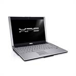
It’s a Dell XPS M1330 – Core 2 Duo at 2.2 GHz, 320 GB hard disk, 4GB RAM and a WLED display, and, amazingly for Dell, it’s stylish and light. Also, best of all, you can buy it from Dell with Linux pre-installed! It probably would have been the same price to buy it with Vista, have a good laugh, and then wipe it and install Ubuntu anyway, but I wanted to show my support for what Dell are doing here.
On the whole, I love it. But there was one issue that was driving me up the wall. I bought with it a nice external 24″ Dell LCD monitor. But could it be configured to work with the stock Ubuntu install? No. Experimenting with the Ubuntu settings in the administration section just seemed to make things worse. Googling for advice brings up nothing useful, apart from lots of people complaining about the same thing. I saw some advice somewhere to run “nvidia-settings”, which I hadn’t yet tried. Not as useful as I thought it was going to be…
Cowon D2
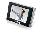
I’ve been thinking about upgrading my music player for ages – I had a Rio Karma, which I liked because it natively played OGG format and was usable under Linux. However it’s pretty big compared to today’s players. I then bought an iPod Nano, only because I knew that I could replace the firmware with Rockbox, which gave it the ability to work with Linux and play OGGs. But there were too many niggling problems – the major one for me is no ability to upgrade the memory.
usb_set_configuration failed
If you’ve been trying to transfer a GPX file to your GPS unit from a Linux machine, using GPSBabel, and have seen this message:
$> gpsbabel -r -i gpx -f FOO.gpx -o garmin -F usb:
usb_set_configuration failed, probably
because kernel driver 'garmin_gps' is
blocking our access to the USB device.
…then don’t despair. Help is here. Continue reading “usb_set_configuration failed”
Can’t Click Your Waypoints?
If you are using the Marengo GPS Route Planner on Internet Explorer you may have noticed that, since January 8th (or thereabouts), you won’t have been able to click or drag any waypoints you lay down on a route.
This is a result of some incorrect data being updated by Google themselves in a recent update to the Maps service.
Fortunately there’s a fix. They’ve amended their error (today), but it requires that you do the following to make it effective:
Open up the route planner, and, while holding down Ctrl, press the browser’s page reload (Refresh) button. This will cause the cache on your browser to be updated and allow the Google fix to be used.
Asus EEE and Mercury
If you are even a semi-geek you surely have heard of the Asus EEE PC – the tiny £200 Linux laptop that is selling like hot cakes.
Naturally I ordered one as soon as it was announced in the UK… and I have to say it’s brilliant. Coupled with a Huawei E220 mobile modem (the one that Three.co.uk are pushing in their “mobile broadband” campaign) it’s a go-anywhere marvel. I regularly use it for development while on the tube, commuting to and from work.
One of the fruits of this extra development time is Mercury, a very basic (at this stage) Quicksilver-type launcher for Linux, but with very few dependencies. Katapult, for example, is more full-featured, but on the EEE requires a huge amount of extra upgrades to allow it to run. Mercury runs without anything else (as far as I can tell :)
Anyway, get it here: http://www.marengo-ltd.com/mercury/